Property Research in Montgomery County
Researching property in Montgomery County can be tricky, but there is a lot to discover once you begin. The process can take many directions, and involve lots of different kinds of resources depending on:
- Where your property is located
- The time period you are interested in researching
- The resources available (sometimes dependent on the answers above)
Use the information below to understand the different types of resources available and remember you can always contact us for assistance, or make a research appointment to access even more services.

Start with Maps
Depending on where your property is located, there may be information on it embedded in several Montgomery County maps and atlases throughout the years, described and available to access on the page linked below. 19th century coverage is limited to only three county-wide maps and a couple DC-adjacent portions, while 20th century coverage is more detailed, but tends to favor lower-county locations.
If you’re not finding what you’re looking for, you may need to continue on to deed research or other resources. You can always contact us for assistance or make an appointment to get help with your research project.
Maps and Atlases →
Search the Deeds
Deed research in Maryland can be a complicated and very time-consuming process, due to the way land records have been written and filed. No comprehensive chain of ownership list exists for any property—each must be assembled one deed at a time by working either backwards from a current deed or forwards from an original patent or known landowner.
Property deeds only describe the piece of land sold—there is no information in the land records that indicates the build date of houses or other structures. Such information can sometimes be inferred, but is not present in the documents.
Starting with SDAT
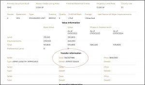
You can start with the recent sales of the property by searching on an address using the SDAT’s website (State Department of Assessments and Taxation).
Follow the instructions to find the current owner of any property.
The page will usually refer you to a few previous sales under “Transfer Information.”
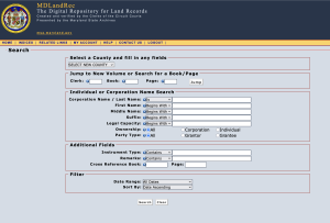
Using MDlandrec:
To get further back in time than the sales listed there, you must continue your search manually through the deeds, which are available online through the Maryland State Archives database. You have to create an account (username/password) to use the database, but it is free with a valid email address.
The land records are NOT indexed by address, as properties were not always defined by modern-day street addresses.
Instead, to determine chain of ownership you need to work backwards through the land deeds, using either:
1. A deed reference. The deed reference (from SDAT or from another source) will have two numbers separated by a backslash– something like 252/00059. That refers to “book” / “page” respectively.
-OR-
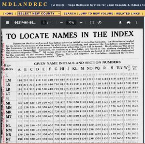
2. The full name of a previous property owner. Unless there is an inheritance involved, the property owner will usually appear twice in the records, once as the “Grantee” (the buyer) and once as the “Grantor” (the seller). Grantees and Grantors are separated into two separate indices within the database. Searching those indices involves using a soundex on the seller’s name (grantor) to find the correct index for a certain range of dates.
Soundex tool for finding deeds by grantor or grantee names.
Most 20th-century deeds, somewhere within the text, will provide a reference with book and page number to the previous sale (option 1 above). At a certain point back in time, the land will only be described by patent title and metes/bounds– you must then look up prior deeds according to the seller, who should be listed in the grantee index as the previous buyer (option 2 above). Also be aware that the deeds prior to about the 1920s are usually hand-written in script.
The State Archives has an FAQ page for using the site.
For a tutorial on how to use the soundex for searching in Montgomery County, see this video
Original Patent Names
Many deeds will refer to the original patent title of the piece of property, which have colorful names such as “Bite the Biter,” “Magruder’s Folly,” or “Chiswell’s Inheritance.” These refer to the original name given to each piece of land when granted by the Lord Baltimore in the 18th century.
Fortunately, we have the footprints of the original patents mapped through 1800 for all regions of Montgomery County, as part of an extensive project undertaken by a group of volunteers in the 1990s.
Read about their process of turning “metes and bounds” into locational coordinates in this article
The original patents are drawn on a transparent overlay, which can be superimposed on a modern-day base map to determine the approximate boundaries of those pieces of land today. The maps are not digitized, because the multi-layer information can be visually confusing in two dimensions. For access to these valuable maps, contact the Archivist/Librarian at the Jane Sween Research Library.
You can also search for the existence of original patents drawn by surveyors at the Maryland State Archives: Montgomery County Patents Index
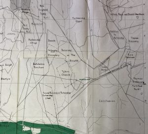
Sample image of the overlay of original patents atop the modern-day base map, Poolesville region.
Additional Information and Assistance
The Land Records office in the Montgomery County Circuit Court building can be of assistance in locating difficult property deeds.
If you are looking for plats of subdivisions, you can search plats.net through the Maryland State Archives. For a tutorial on how to use the site for plats, see this video.
In the case of an inheritance, especially property contested in Probate Court, property may be divided and described in the Probate Records, or sometime in the Equity Papers, both held by the Maryland State Archives. The indices are searchable online, but the records themselves must be accessed in their reading room in Annapolis.
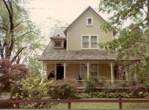
House History
There is no information in the land records that indicates the build date of houses or other structures. Such information can sometimes be inferred, but is not present in the documents. To research the history of a house or other building, you must consult other sources. The following resources may be helpful in learning more about your house. For further assistance, contact the Archivist/Librarian or make an appointment to visit the library.
Maryland Historical Trust
Interactive map and other resources to identify and learn about homes on the historic register in Montgomery County.
Klinge Real Estate Atlases, 1931-1959
These indexed atlases show property ownership and subdivision development throughout the mid-20th century. Maps include property owners (in the case of larger tracts) and Liber/Folio numbers referring to Montgomery County land records, as well as footprints of houses and other structures within developments. Coverage is limited to property south of Rockville.
Montgomery Mutual Fire Insurance policy documents, 1848-1910s
Some homeowners took out insurance policies on their buildings– dwelling houses, barns, outbuildings, and tenant houses–and described those structures in their applications for that insurance. Policies are searchable on owner surname and location.
Historic House files (Jane C. Sween Research Library)
Many houses with longevity in the county are represented in these files of clippings, written histories, and research. Not comprehensive, they can be searched by address or estate title (e.g. “Montevideo”).
Note: Blueprints of houses are extremely rare! Blueprints are generally the intellectual property of the architect or builder and do not convey either to owners nor are they filed with the county (in most cases). They are not public records and are not required to be archived in any public repository. In some incorporated areas, house plans must be filed with the town office; in all other areas such documents likely conveyed with the individual firms and/or were discarded at the creators’ discretion. These collections represent the only blueprints held by Montgomery History.
Redlining and Restrictive Covenants
Various types of legal housing discrimination existed during the 19th and 20th century that specifically affected Black residents of Montgomery County for generations, and contributed to a lasting disparity of homeownership and housing wealth along racial lines. The existence and pervasiveness of restricted covenants associated with Montgomery County’s suburban neighborhood developments is undeniable, but the historical evidence is still being mapped and studied. To learn more, we encourage you to explore the following resources:
Mapping Segregation Project (Montgomery Planning)
Takoma Park Covenants Project (Historic Takoma)
Mapping Segregation in Washington D.C. (Prologue DC)
On November 14, 2024, Montgomery History, in partnership with Montgomery County Lynching Memorial Project, presented “From Restrictive Covenants to Redlining: The National History of Housing Segregation.” This virtual talk with Dr. Paige Glotzer, Associate Professor of History at the University of Florida and author of How the Suburbs Were Segregated, contextualizes Montgomery County within a national history of housing segregation. Beginning with restrictive covenants and nuisance laws, it traces the people, policies, and tools that made segregation an inescapable part of the American landscape. Topics include housing discrimination and violence, redlining, and urban renewal, as well as the relationship between race and property value. It also asks why housing segregation remained profitable even as attitudes about inequality changed. Audience members are invited to consider the hidden legacies of old practices and how they still impact the US today. Click below to view the presentation.
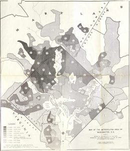
Map of the Metropolitan Area of Washington, D.C. in 1937, showing division of the Metropolitan Area into Residential Sub-Areas.